
Green Sky Group
Drone Inspections & Drone Surveying Services
Case Studies
We are committed of helping Australian businesses and organisations
case studies
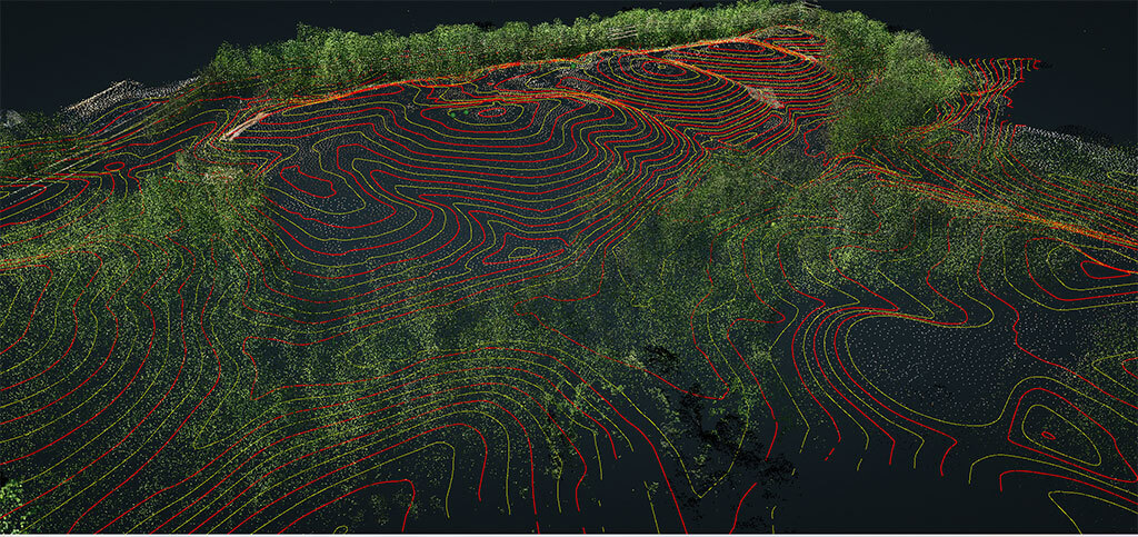
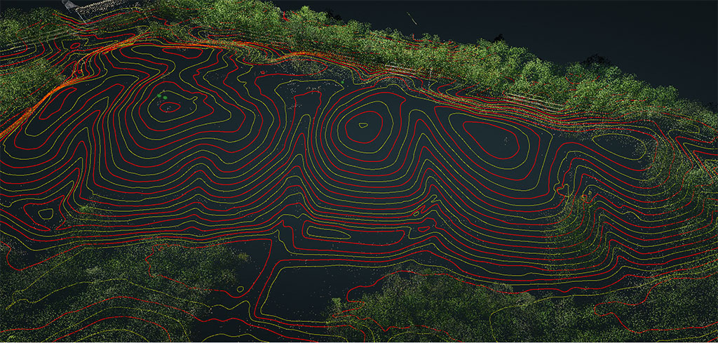
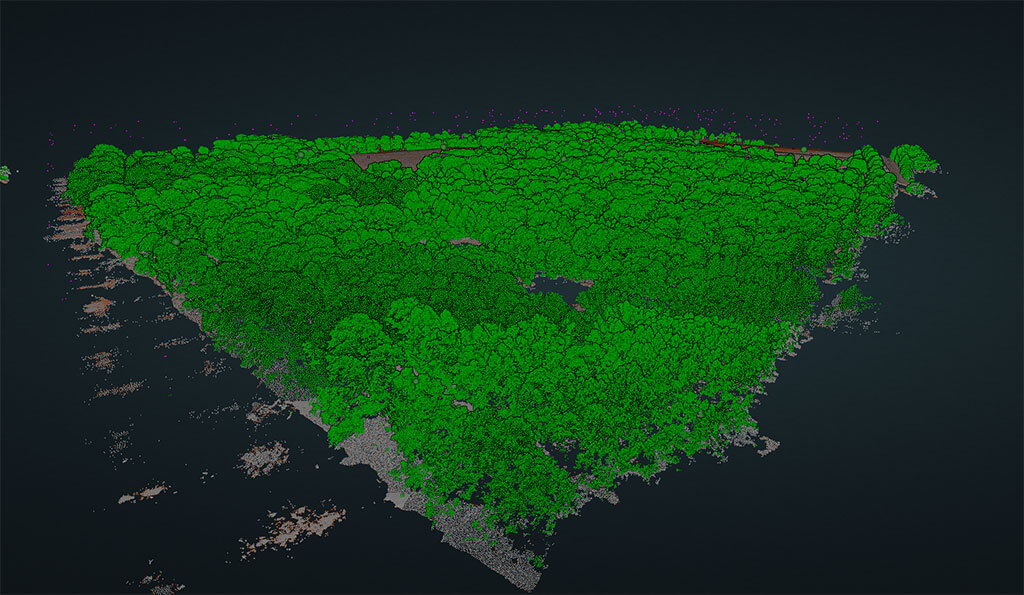
Drone Lidar Land Survey Case Study in Queensland

Overview
Green Sky was engaged by a client to conduct a survey of approx. 36ha of land in Queensland. The purpose of the survey was to capture high-accuracy data for land planning purposes as well as inspecting areas that were inaccessible due to poor terrain access. Green Sky used the DJI M300 RTK with DJI L1 drone for the survey. Two EMLID RS2+ GNSS receivers were used; one was used as a base station and the other as a rover to lay many ground control points (GCPs) The survey required the use of PPK (post-processed kinematic) to achieve an accuracy of 5cm.
Challenge
The main challenge of the project was to capture high-accuracy data over a large area of land, while also producing a 3D model that showed accurate contours for land planning. The location of the site also presented challenges, as it was in a remote area without reliable mobile coverage, as well as difficult and hard to reach areas.
Process
Green Sky worked closely with the landowner to define the deliverables required for the project. Prior to the flight operation, we confirmed the land boundary with the owner via a KML to ensure complete site coverage. Green Sky set up the EMLID RS2+ as a base station. GCP’s were placed throughout the parcel of land at different locations and elevations with the EMLID R2S+ rover. In the DJI M300 drone remote, the terrain follow mode were activated and a flight altitude of 50m AGL was selected. 3 different take off/landing locations were required to maintain visual line of sight (VLOS) throughout the drone flight.
To process the surveying data, we used specialized cloud software that allowed us to create and share a 3D model representing the land's contours accurately. Since we couldn't use RTK, we relied on PPK to achieve centimetre-level accuracy. This technique involved using two EMLID RS2+ GNSS receivers, with one acting as a base station and the other as a rover. The resulting data was then post-processed using PPK to ensure the highest possible accuracy.
Result
The data captured by Green Sky was provided to the client in the form of high-resolution photos, LiDAR data, and a 3D model of the land. The client was able to use the data for land planning purposes and to make informed decisions about the development of the land. The use of ground control points and PPK ensured that the data was accurate to within a few centimeters, which was crucial for the planning and development of the site.
Conclusion
Green Sky was able to overcome the challenges of capturing high-accuracy data over a large area of land, while also producing a 3D model that accurately represented the contours of the land. The use of the DJI L1 drone and ground control points, combined with post-processing using specialized software and PPK, ensured that the data was accurate to within the required 5cm. The client was ecstatic with the results and was able to use the data for land planning purposes.
Output
Green Sky provided the client with high-resolution photos, LiDAR data, and a 3D model of the land. The data was used for land planning purposes and to make informed decisions about the development of the land. The use of ground control points and PPK ensured that the data was accurate to within 5cm, which was crucial for the planning and development of the site.
More case studies
Drone Surveying? Drone Asset Inspections? Marketing & Media. We Do It All.
Book a discovery call today to see how our drones will improve your business operations.

![]() “Quick to respond and super helpful. Results speak for themselves. Thank you Green Sky Photography for such a great effort, especially with the timing demand we put on you.”
“Quick to respond and super helpful. Results speak for themselves. Thank you Green Sky Photography for such a great effort, especially with the timing demand we put on you.”
KEVIN S. | MURGON QLD
![]() “Alli and the team at Green Sky Photography went over and beyond for us. Their professionalism is second to none, that is to say we would highly recommend their services.”
“Alli and the team at Green Sky Photography went over and beyond for us. Their professionalism is second to none, that is to say we would highly recommend their services.”
MIKE C. | MURGON QLD
![]() “Jamie is a great communicator and he did a fantastic job of our drone photos. He totally anticipated our needs and delivered well and above and in a very short turnaround time. Would definitely recommend using his services..”
“Jamie is a great communicator and he did a fantastic job of our drone photos. He totally anticipated our needs and delivered well and above and in a very short turnaround time. Would definitely recommend using his services..”
HEATHER H. | ENOGGERA QLD
![]() “It has been an easy and amazing experience to work with Jamie. He was really responsive and professional. The photos are great and I highly recommend Green Sky Photography Drone Services!.”
“It has been an easy and amazing experience to work with Jamie. He was really responsive and professional. The photos are great and I highly recommend Green Sky Photography Drone Services!.”
JP M.
![]() “Jamie was a massive help when I needed to rent a drone ASAP, and his advice and guidance throughout the process came at no extra cost, all of which was extremely helpful and useful for further projects.”
“Jamie was a massive help when I needed to rent a drone ASAP, and his advice and guidance throughout the process came at no extra cost, all of which was extremely helpful and useful for further projects.”
RICHARD M
![]() “The team from Green Sky Photography were fantastic to deal with. We are a ground-penetrating radar surveying company, and we required a drone on extremely short notice to survey a job in Coober Pedy. Jamie was extremely accommodating.”
“The team from Green Sky Photography were fantastic to deal with. We are a ground-penetrating radar surveying company, and we required a drone on extremely short notice to survey a job in Coober Pedy. Jamie was extremely accommodating.”
AIDEN W
![]() “Highly recommend Green Sky Photography Drone services. The company has a reliable and well-communicated professional drone team that we always trust in their skills and professionalism. Their prices are very competitive and the outcome is very detailed and of high quality.”
“Highly recommend Green Sky Photography Drone services. The company has a reliable and well-communicated professional drone team that we always trust in their skills and professionalism. Their prices are very competitive and the outcome is very detailed and of high quality.”
NASER H
![]() “Alli & Jamie performed some beautiful and steady low flying over my property. Clear photography and footage. Lovely couple, friendly and happy to answer all my questions. Thanks guys 👌😊.”
“Alli & Jamie performed some beautiful and steady low flying over my property. Clear photography and footage. Lovely couple, friendly and happy to answer all my questions. Thanks guys 👌😊.”
KATHLEEN M
![]() “Green Sky exceeded my expectations and I would not hesitate to recommend their services. Jamie communicated well and I am pleased with the range of photos taken.”
“Green Sky exceeded my expectations and I would not hesitate to recommend their services. Jamie communicated well and I am pleased with the range of photos taken.”
BEN S
![]() “Alli and the team at Green Sky Photography went over and beyond for us. Their professionalism is second to none, that is to say we would highly recommend their services..”
“Alli and the team at Green Sky Photography went over and beyond for us. Their professionalism is second to none, that is to say we would highly recommend their services..”
MIKE C
Sign Up to our Newsletter to know more about our services
Company
Services
Follow Us

© 2017-2024 Green Sky Group Pty Ltd.
CASA ReOC 6846
All Rights Reserved